


190-00728-04 Rev. A
Embraer Prodigy
®
Flight Deck 100 Pilot’s Guide
498
ADDITIONAL FEATURES
8.1 SYNTHETIC VISION SYSTEM (SVS)
WARNING:
Use appropriate primary systems for navigation, and for terrain, obstacle, and traffic avoidance.
SVS is intended as an aid to situational awareness only and may not provide either the accuracy or reliability
upon which to solely base decisions and/or plan maneuvers to avoid terrain, obstacles, or traffic.
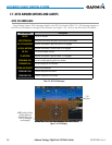
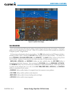
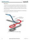
The optional SyntheticVisionSystem(SVS)isavisualenhancementtotheProdigy
®
FlightDeck100.SVS
depictsaforward-lookingattitudedisplayofthetopographyimmediatelyinfrontoftheaircraft.Theeldof
viewis30degreestotheleftand35degreestotheright.SVSinformationisshownonthePrimaryFlightDisplay
(PFD),orontheMultifunctionDisplay(MFD)inReversionaryMode(Figure8-132).Thedepictedimageryis
derivedfromtheaircraftattitude,heading,GPSthree-dimensionalposition,andaninearc-seconddatabaseof
terrain, obstacles,and otherrelevantfeatures. The terraindata resolution of ninearc-seconds, meaningthat
theterrainelevationcontoursarestoredinsquaresmeasuringninearc-secondsoneachside,isrequiredforthe
operationofSVS.Lossofanyoftherequireddata,includingtemporarylossoftheGPSsignal,willcauseSVSto
bedisableduntiltherequireddataisrestored.
TheSVSterraindisplayshowslandcontours(colorsareconsistentwiththoseofthetopographicalmapdisplay),
largewaterfeatures,towers,andotherobstaclesover200’AGLthatareincludedintheobstacledatabase.Cultural
featuresonthegroundsuchasroads,highways,railroadtracks,cities,andstateboundariesarenotdisplayed
evenifthosefeaturesarefoundontheMFDmap.Theterraindisplayalsoincludesanorth–southeast–westgrid
withlinesorientedwithtruenorthandspacedatonearc-minuteintervalstoassistinorientationrelativetothe
terrain.
TheTerrainAwarenessandWarningSystem(TAWS)isintegratedwithinSVStoprovidevisualandauditory
alertstoindicatethepresenceofterrainandobstaclethreatsrelevanttotheprojectedightpath.Terrainalerts
are displayed in red and yellow shading on the PFD.
Theterraindisplayisintendedforsituationalawarenessonly.Itmaynotprovidetheaccuracyordelityon
whichtobasedecisionsandplanmaneuverstoavoidterrainorobstacles.Navigationmustnotbepredicated
solelyupontheuseoftheTAWSterrainorobstacledatadisplayedbytheSVS.
The following SVS enhancements appear on the PFD:
•Pathways
•FlightPathMarker
•HorizonHeadingMarks
•TrafcDisplay
•AirportSigns
•RunwayDisplay
•TerrainAlerting
•ObstacleAlerting