


190-00728-04 Rev. A
Embraer Prodigy
®
Flight Deck 100 Pilot’s Guide
333
HAZARD AVOIDANCE
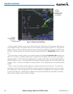
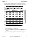
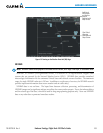
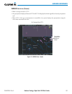
Figure 6-9 Panning on the Weather Data Link (XM) Page
Additional
Information
on Weather
Feature
Selected with
Map Pointer
Flash Flood
Warning
Selected with
Map Pointer
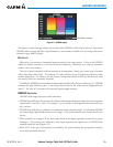
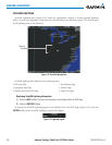
NEXRAD
NOTE: NEXRAD cannot be displayed at the same time as terrain, echo tops, cloud tops, or turbulence data.
WSR-88D, or NEXRAD (NEXt-generation RADar), is a network of 158 high-resolution Doppler radar
systems that are operated by the National Weather Service (NWS). NEXRAD data provides centralized
meteorologicalinformationforthecontinentalUnitedStatesandselectedoverseaslocations.Themaximum
rangeofasingleNEXRADradarsiteis250nm.Inadditiontoawidearrayofservices,theNEXRADnetwork
provides important information about severe weather and air traffic safety.
NEXRAD data is not real-time. The lapsed timebetween collection, processing, and dissemination of
NEXRADimagescanbesignicantandmaynotreectthecurrentradarsynopsis.Duetotheinherentdelays
andtherelativeageofthedata,itshouldbeusedforlong-rangeplanningpurposesonly.NeveruseNEXRAD
data or any radar data to penetrate hazardous weather.