


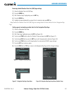

190-00728-04 Rev. A
Embraer Prodigy
®
Flight Deck 100 Pilot’s Guide
335
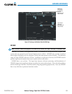
HAZARD AVOIDANCE
No Radar Coverage
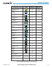
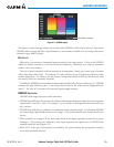
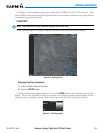
Figure 6-11 NEXRAD Legend
ThedisplayofradarcoverageisalwaysactivewheneitherNEXRADorEchoTopsisselected.Areaswhere
NEXRADradarcoverageandEchoTopsinformationisnotcurrentlyavailableorisnotbeingcollectedare
indicated in gray shade of purple.
reflectivity
Reectivityistheamountoftransmittedpowerreturnedtotheradarreceiver.ColorsontheNEXRAD
displayaredirectlycorrelativetothelevel ofdetectedreectivity.Reectivityasitrelatestohazardous
weathercanbeverycomplex.
Theroleofradarisessentiallytodetectmoistureintheatmosphere.Simplyput,certaintypesofweather
reectradarbetterthanothers.Theintensityofaradarreectionisnotnecessarilyanindicationofthe
weatherhazardlevel.Forinstance,wethailreturnsastrongradarreection,whiledryhaildoesnot.Both
wetanddryhailcanbeextremelyhazardous.
ThedifferentNEXRADechointensitiesaremeasuredindecibels(dB)relativetoreectivity(Z).NEXRAD
measures the radar reflectivity ratio, or the energy reflected
back to
theradarreceiver(
designated by the
letterZ)
.ThevalueofZincreasesasthereturnedsignalstrengthincreases.
neXraD limitations
NEXRADradarimagesmayhavecertainlimitations:
•NEXRADbasereectivitydoesnotprovidesufcientinformationtodeterminecloudlayersorprecipitation
characteristics(wethailvs.rain).Forexample,itisnotpossibletodistinguishbetweenwetsnow,wet
hail, and rain.
•NEXRADbasereectivityissampledattheminimumantennaelevationangle.AnindividualNEXRAD
sitecannotdepicthighaltitudestormsatcloseranges.Ithasnoinformationaboutstormsdirectlyover
the site.
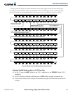
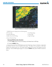
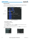
•Whenzoomedintoarangeof30nm,eachsquareblockonthedisplayrepresentsanareaoffoursquare
kilometers.Theintensitylevelreectedbyeachsquarerepresentsthe
highest
levelofNEXRADdata
sampledwithinthearea(Figure6-12).
•Below52ºN,ifthetypeofprecipitationisunavailable,thesystemdisplaystheprecipitationusingthe
color codes associated with rain.