


190-00728-04 Rev. A
Embraer Prodigy
®
Flight Deck 100 Pilot’s Guide
33
SYSTEM OVERVIEW
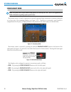
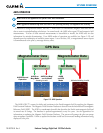
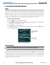
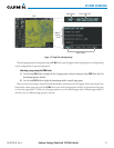
The GPS Status Page provides the following information:
•Satelliteconstellationdiagram
Satellites currently in view are shown at their respective positions on a sky view diagram. The sky view is
always in a north-up orientation, with the outer circle representing the horizon, the inner circle representing
45° above the horizon, and the center point showing the position directly overhead.
Each satellite is represented by an oval containing the Pseudo-random noise (PRN) number (i.e., satellite
identification number). Satellites whose signals are currently being used are represented by solid ovals.
•Satellitesignalinformationstatus
The accuracy of the aircraft’s GPS fix is calculated using Estimated Position Uncertainty (EPU), Dilution
of Precision (DOP), and horizontal and vertical figures of merit (HFOM and VFOM). EPU is the radius of a
circle centered on an estimated horizontal position in which actual position has 95% probability of laying.
EPU is a statistical error indication and not an actual error measurement.
DOP measures satellite geometry quality (i.e., number of satellites received and where they are relative to
each other) on a range from 0.0 to 9.9, with lower numbers denoting better accuracy. HFOM and VFOM,
measures of horizontal and vertical position uncertainty, are the current 95% confidence horizontal and
vertical accuracy values reported by the GPS receiver.
The current calculated GPS position, time, altitude, ground speed, and track for the aircraft are displayed
below the satellite signal accuracy measurements.
•GPSreceiverstatus
The selected GPS receiver is indicated for the pilot and copilot display.
The GPS solution type (ACQUIRING, 2D NAV, 2D DIFF NAV, 3D NAV, 3D DIFF NAV) for the active GPS
receiver (GPS1 or GPS2) is shown in the upper right of the GPS Status Page. When the receiver is in the process
of acquiring enough satellite signals for navigation, the receiver uses satellite orbital data (collected continuously
from the satellites) and last known position to determine the satellites that should be in view. ACQUIRING is
indicated as the solution until a sufficient number of satellites have been acquired for computing a solution.
When the receiver is in the process of acquiring a 3D navigational GPS solution, 3D NAV is indicated as the
solution until the 3D differential fix has finished acquisition. SBAS (Satellite-Based Augmentation System) will
indicate INACTIVE. When acquisition is complete, the solution status will indicate 3D DIFF NAV and SBAS
will indicate ACTIVE.
•RAIM(ReceiverAutonomousIntegrityMonitoring)Prediction(RAIM Softkey is selected)
In most cases performing a RAIM prediction will not be necessary. However, in some cases, the selected
approach may be outside the SBAS coverage area and it may be necessary to perform a RAIM prediction for the
intended approach.
Receiver Autonomous Integrity Monitoring (RAIM) is a GPS receiver function that performs a consistency
check on all tracked satellites. RAIM ensures that the available satellite geometry allows the receiver to calculate
a position within a specified RAIM protection limit (2.0 nautical miles for oceanic and enroute, 1.0 nm for
terminal, and 0.3 nm for non-precision approaches). During oceanic, enroute, and terminal phases of flight,
RAIM is available nearly 100% of the time.
The RAIM prediction function also indicates whether RAIM is available at a specified date and time. RAIM
computations predict satellite coverage within ±15 min of the specified arrival date and time.