


190-00728-04 Rev. A
Embraer Prodigy
®
Flight Deck 100 Pilot’s Guide
23
SYSTEM OVERVIEW
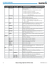
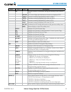
Level 1 Level 2 Level 3
Description
LFE
Accesses softkeys for manually setting the Landing Field Elevation
(LFE)
FMS LFE
Sets current flight plan destination elevation as displayed LFE
+500 FT
Increases currently displayed LFE value by 500 ft
-500 FT
Decreases currently displayed LFE value by 500 ft
+50 FT
Increases currently displayed LFE value by 50 ft
-50 FT
Decreases currently displayed LFE value by 50 ft
ACCEPT
Confirms the LFE setting and returns to the previous softkey level
BACK
Returns display to previous softkey level
STATUS
Displays the System-Status Page
ECS
Displays the System-ECS (Environmental Control System) Page
ELEC
Displays the System-Electrical Page
FUEL
Displays the System-Fuel Page
ICEPROT
Displays the System-Deice Page
ENG MNT
Displays the Engine Maintenance Page. Enabled only while aircraft
is on the ground and engines are off.
BACK
Returns display to previous softkey level
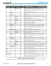
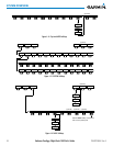
MAP
Enables second-level Navigation Map softkeys
TRAFFIC
Displays traffic information on Navigation Map
TOPO
Displays topographical data (e.g., coastlines, terrain, rivers, lakes)
and elevation scale on Navigation Map
TERRAIN
Displays terrain information on Navigation Map (not available with
TAWS-A)
AIRWAYS
(Default label
is dependant
on map
setup option
selected)
Displays airways on the map; cycles through the following:
AIRWAYS: No airways are displayed
AIRWY ON: All airways are displayed
AIRWY LO: Only low altitude airways are
displayed
AIRWY HI: Only high altitude airways are displayed
NEXRAD
Displays NEXRAD weather and coverage information on the
Navigation Map (optional feature)
XM LTNG
Displays SiriusXM Weather lightning information on the
Navigation Map (optional feature)
METAR
Displays METAR flags on airport symbols
BACK
Returns to top-level softkeys
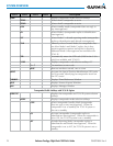
DCLTR (3)
Selects desired amount of map detail; cycles through declutter levels:
DCLTR (No Declutter): All map features visible
DCLTR-1: Declutters land data
DCLTR-2: Declutters land and SUA data
DCLTR-3: Removes everything except the active flight plan
SHW CHRT
When available, displays optional airport and terminal procedure charts