


Chart Alarms · 213
Chart Alarms
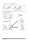
General
The ECDIS is defined to increase safety with capability of detecting areas where depth is less than Safety contour or
where specified conditions exists. If you plan a route or if prediction of own ship movement goes across safety
contour or an area where selected specified condition exist, the system will give an indication or alarm for danger
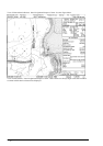
area In this operation the ECDIS utilises chart database (S57 charts) stored on hard disk in SENC format. Note that
ECDIS calculates dangerous areas using the largest scale chart available which may not be the visualised chart.
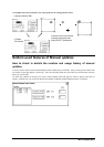
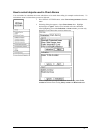
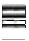
You can select objects which are included for calculation of danger area (For example restricted areas). There is a
list of various areas which can cause indication of danger.
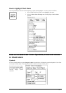
You can also define your own safe area by creating a User Chart Area. The system can utilise these areas when
calculating chart alarms. This is very useful with raster chart material such as ARCS.
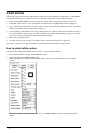
The ECDIS can check for you
· predicted movement area of the own ship
· planned route with an easy to use locator function to find dangerous areas
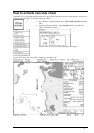
The ECDIS will highlight for you on the chart area
· dangerous areas inside predicted movement area of the own ship
· dangerous areas inside your monitored route
· dangerous areas inside your planned route