


Route planning · 233
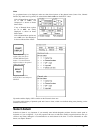
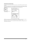
Route planning
Introduction
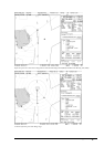
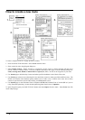
A route plan is complete navigation plan from starting point to the final destination. The plan includes:
· Route name
· Name, Lat and Lon of each waypoint
· Radius of turn circle at each waypoint
· Safe channel limits
· Chart Alarm calculation based on channel limits against chart database and User Chart danger
· Deadband width
· Minimum and maximum speed for each leg
· The navigation method (rhumb line, great circle)
· Fuel saving
· ETD for the first waypoint
· ETA for the last waypoint
· Ship and environmental condition affecting the ship speed calculation
· Name of the User Chart planned to be used during Route Monitoring together with this Planned Route
· Name of the Pilot Data planned to be used during Route Monitoring together with this Planned Route
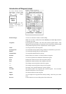
The system calculates using this data; speed, course and length for each leg, ETAs for each waypoint, fuel
consumption and WOP for the trackpilot and also calculates safe water areas based on user defined channel limits.
The calculated data is displayed in a tabular form which can be printed as a documented route plan and also stored in
a file for later use. The route files thus formed contains the trackpilot commands for each waypoint.
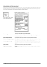
Main functions of this Route Planning are:
· Define waypoints
· Define turnings for each waypoint
· Define channel limits for each leg (leg is the line connecting two waypoints together). The channel limits are
used to detect Chart Alarms when you are planning or monitoring your route. See also chapter "Chart Alarm
calculation"
· Define the speed for each leg
· Enable a calculation for ETD and ETA
· Enable a calculation for most economical sailing