


Definition of Terms · 431
Definition of Terms
List of terms
APPROACHING POINT (AP)
A user selected point where a turning alarm is initiated.
AUTOMATIC RADAR PLOTTING AID (ARPA)
A system wherein radar targets are automatically acquired, tracked and collision situations computer assessed and
warning given.
CHANNEL LIMIT (CHL)
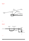
During route planning a channel limit is defined for each leg. This limit can also be the border line of the chart
shown on the radar display. "For more information, see "Figure 1" on page 434.
COURSE
Course is the horizontal direction in which a craft is steered or intended to be steered, expressed as angular distance
from north, usually from 000º at north, clockwise through 360º. Strictly, course applies to direction through the
water, not the direction intended to be made good over the ground.
COURSE OVER GROUND (COG)
The direction of the path over ground actually followed by a craft. For more information, see "Figure 1" on page
434.
CLOSEST POINT OF APPROACH (CPA)
A user can set CPA limit.
DATUM
A set of parameters specifying the reference surface or the reference co-ordinate systems used for geodetic control in
the calculation of co-ordinates of points on the earth. Commonly datum is defined as horizontal and vertical datum
separately. For the practical use of the datum it is necessary to have one or more well monument points with co-
ordinates given in that datum.
ELECTRONIC CHART DISPLAY AND INFORMATION SYSTEM (ECDIS)
The navigation information system which is considered equivalent to the nautical paper chart, displaying selected
information from the chart data base (see ENC) integrated with data from positional and, optionally other sensors.
By displaying chart contents and optionally other chart related and navigational information, ECDIS assists the
mariner in route planning and, with on-line position indication, in route monitoring.