


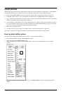

216 · Chart Alarms
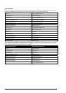
List of areas
There are the areas which ECDIS detects and provides an alarm or indication if estimated own ship position or
planned or monitored route across the area. You can select following areas in Chart Alarms sheet.
Fairway Cargo Transhipment Area
Restricted Area User Chart Danger
Caution Area Traffic Separation Zone
Offshore Production Area TRS Crossing/Roundabout
Military Practise Area TRS Precautionary Area
Seaplane Landing Area Two Way Traffic Route
Submare Transit Lane Deep Water Route
Fishing Ground Recommended Traffic Line
Pipeline Area Inshore Traffic Zone
Cable Area Ice Area
Anchorage Area Channel
Anchorage Prohibited Fishing Prohibited
Dumping Ground Spoil Ground
Incineration Area Dredged Area
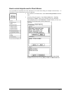
Note! Areas To Be Avoided and Specially Protected Areas are collections of certain type of areas. If you select
either of them, a group of areas will cause alarm or indication. A table below shows which areas are selected if
Areas To Be Avoided or Special Protected Areas is selected.
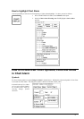
Areas To Be Avoided Specially Protected Areas
Fairway Fishing Ground
Restricted Area Pipeline Area
Caution Area Cable Area
Offshore Production Area Anchorage Area
Military Practise Area Anchorage Prohibited
Seaplane Landing Area Dumping Ground
Submare Transit Lane Incineration Area
Cargo Transhipment Area