


432 · Definition of Terms
ELECTRONIC NAVIGATIONAL CHART (ENC)
The database held on the ship for use with ECDIS. The ENC is equivalent to new editions of paper charts, and may
contain additional supplementary nautical information additional to that contained in the paper chart.
FORWARDING DISTANCE (F)
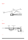
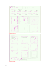
The distance which the vessel moves straight after a rudder command. "For more information, see "Figure 2" on
page 434.
"FROM WP"
The last passed waypoint. For more information, see "Figure 1" on page 434.
HEADING (HDG)
The horizontal direction in which the longitudinal axis of a ship actually points or heads at any instant, expressed as
angular units from a reference direction, usually from 000º at the reference direction, clockwise through 360º (true,
magnetic or compass heading). For more information, see "Figure 1" on page 434.
GREAT CIRCLE
The intersection of the surface of a sphere and a plane through its center.
MAGNETIC VARIATION
The angle between the magnetic and geographic meridians at any place, expressed in degrees and minutes east or
west to indicate the direction of magnetic north from true north.
MENU
A list of commands and/or options. The user selects the desired command by moving the cursor to the respective
position on the menu.
"NEXT WP"
The waypoint after "TO WP"
OFF TRACK
Cross track error (XTE) distance from intended track. For more information, see "Figure 1" on page 434.
PLAN
The direction "From WP" to "To WP", a constant course on a rhumb line track and a varying course on a Great
Circle track. For more information, see "Figure 1" on page 434.
POSITION
On the display is indicated which instruments are giving information for the position calculation.