


Definition of Terms · 433
RENC
Regional Electronic Nautical Chart center. RENC is defined by IMO and IHO as the source of SOLAS compliant
Electronic Nautical Charts (ENC), which use S57ed3 coding. An example of such a RENC is the PRIMAR in
Stavanger Norway.
RANGE RING
A range ring is a circle with a defined radius located with its centre at the position of the own ship.
RHUMB LINE
A line on the surface of the earth making the same oblique angle with all meridians. A rhumb line is a straight line on
a rhumb (or Mercator) projection.
ROUTE
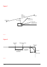
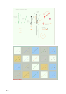
System has internal algorithm to calculate a course to eliminate Off track. For more information, see "Figure 1" on
page 434.
SYSTEM ENC (SENC)
The manufacturer’s own storage formats or data structure for the database.
SPEED OVER GROUND (SOG)
The speed of a craft along the actual path of travel over the ground. For more information, see "Figure 1" on page
434.
"TO WP"
The waypoint which the ship is approaching. For more information, see "Figure 1" on page 434.
VARIABLE RANGE MARKER (VRM)
The VRM is a range ring, the radius of which is continuously adjustable.
WAYPOINT (WP)
The crossing point between two legs.
WHEEL OVER POINT (WOP)
The point where the rudder command is given. "For more information, see "Figure 2" on page 434.
WORLD GEODETIC SYSTEM (WGS)
A consistent set of parameters describing the size and shape of the earth, the positions of a network of points with
respect to the center of mass of the Earth, transformations from major geodetic datum's, and the potential of the
Earth.