


Vector Chart material · 69
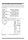
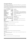
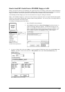
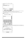
Chart legend of S57 chart
CHART LEGEND is not a pushbutton, but it is a front-page, which is displayed as a base. If you push CANCEL
enough you will finally get CHART LEGEND.
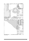
This system is capable to show more than one S57 Chart at the same time. This feature is called multi chart display.
If one S57 Chart does not cover the whole display, the system will open more S57 Chart to be displayed, if they are
available in displayed area. The Chart Legend shows information about S57 Charts displayed on the Electronic chart
display area. The information is displayed from position of own ship, if automatic TM reset is active or from current
position of cursor, if automatic TM Reset is OFF.
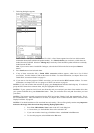
Cell name:
Name of chart.
Navigational purpose:
S57 Charts are compiled for a variety of navigational purposes.
The navigational purpose, for which an individual S57 Chart
has been compiled by a Hydrographic Office, is indicated in
this field. Alternatives are: Overview, General, Coastal,
Approach, Harbour and Berthing
Issue date:
Issue date of the base cell of the chart.
Edition number:
Edition number of the chart.
Last displayed update:
Number of last update, which is visible on the chart screen.
Update issue date:
Issue date of last update, which is visible on the chart screen
Last update appl. date:
Date to which the last update, which is visible on the chart screen, is effective.
Projection:
Projection of the chart. The projection is always Mercator.
Horizontal datum:
Horizontal datum of the chart data as published by the producer of it. By definition this must be WGS 84.
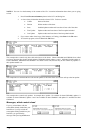
Vertical datum:
Vertical datum of the chart.
Sounding datum:
Datum used for soundings.
Quality of data:
This is a quantitative estimate of the accuracy of chart features given by chart producer.
Magnetic var.:
Amount of magnetic variation. A positive value indicates a change in an easterly direction and a negative value
indicates a change in a westerly direction.
Depth:
Indication of used measurement units of depth.
Height:
Indication of used measurement units above sea level (for example clearance height).